
Shoueifat topographic map
Interactive map
Click on the map to display elevation.
About this map
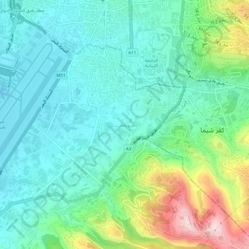
Name: Shoueifat topographic map, elevation, terrain.
Average elevation: 90 m
Minimum elevation: -5 m
Maximum elevation: 346 m
Other topographic maps
Click on a map to view its topography, its elevation and its terrain.
Qarnayel
Lebanon > Mount Lebanon Governorate
Qarnayel, Baabda District, Mount Lebanon Governorate, Lebanon
Average elevation: 1,068 m
Qornet Chahouane
Lebanon > Mount Lebanon Governorate
Qornet Chahouane, Matn District, Mount Lebanon Governorate, Lebanon
Average elevation: 436 m
Rabieh
Lebanon > Mount Lebanon Governorate > Naqqach
Rabieh, Naqqach, Matn District, Mount Lebanon Governorate, 2426, Lebanon
Average elevation: 203 m