
Thank you for supporting this site ❤️
Make a donation
Make a donation
Wittenberg topographic map
Click on the map to display elevation.
Thank you for supporting this site ❤️
Make a donation
Make a donation
About this map
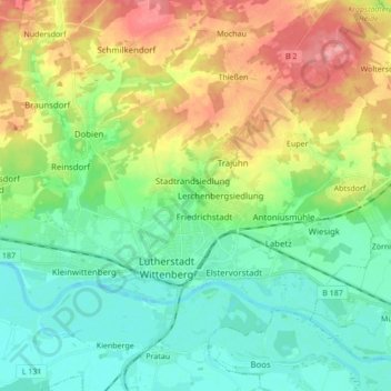
Name: Wittenberg topographic map, elevation, terrain.
Location: Wittenberg, Sachsen-Anhalt, Deutschland (51.85250 12.56645 51.91982 12.73745)
Average elevation: 94 m
Minimum elevation: 61 m
Maximum elevation: 157 m
Thank you for supporting this site ❤️
Make a donation
Make a donation
Other topographic maps
Click on a map to view its topography, its elevation and its terrain.