
Penk topographic map
Interactive map
Click on the map to display elevation.
About this map
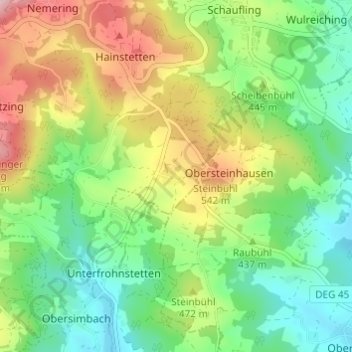
Name: Penk topographic map, elevation, terrain.
Average elevation: 437 m
Minimum elevation: 326 m
Maximum elevation: 625 m
Other topographic maps
Click on a map to view its topography, its elevation and its terrain.
Lalling
Deutschland > Bayern > Landkreis Deggendorf
Lalling, Lalling (VGem), Landkreis Deggendorf, Bayern, 94551, Deutschland
Average elevation: 591 m
Sandgrube
Deutschland > Bayern > Landkreis Deggendorf > Metten
Sandgrube, Metten, Landkreis Deggendorf, Bayern, 94526, Deutschland
Average elevation: 358 m