
Thank you for supporting this site ❤️
Make a donation
Make a donation
Löhma topographic map
Click on the map to display elevation.
Thank you for supporting this site ❤️
Make a donation
Make a donation
Löhma
Löhma liegt im Norden der Stadt auf einer Hochfläche über dem Sormitz- und dem Saaletal in einer Höhe von 520 m in eine Geländesenke.
Thank you for supporting this site ❤️
Make a donation
Make a donation
About this map
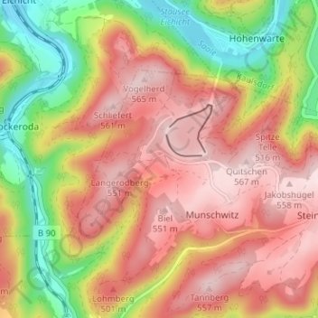
Name: Löhma topographic map, elevation, terrain.
Average elevation: 422 m
Minimum elevation: 235 m
Maximum elevation: 562 m
Thank you for supporting this site ❤️
Make a donation
Make a donation