
Corrientes topographic map
Interactive map
Click on the map to display elevation.
About this map
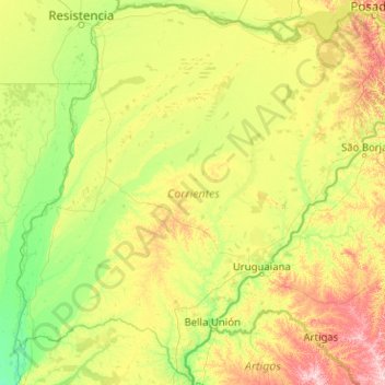
Name: Corrientes topographic map, elevation, terrain.
Location: Corrientes, Argentine (-30.72967 -59.67227 -27.25503 -55.62021)
Average elevation: 70 m
Minimum elevation: 17 m
Maximum elevation: 327 m
Other topographic maps
Click on a map to view its topography, its elevation and its terrain.
Ifrán
Argentine > Corrientes > Ifrán
Ifrán, Municipio de Yatay Tí Calle, Departamento Lavalle, Corrientes, W3453XAF, Argentine
Average elevation: 66 m