
Thank you for supporting this site ❤️
Make a donation
Make a donation
Ghazipur topographic map
Click on the map to display elevation.
Thank you for supporting this site ❤️
Make a donation
Make a donation
Ghazipur
Ghazipur is located at 25°35′N 83°34′E / 25.58°N 83.57°E / 25.58; 83.57. It has an average elevation of 62 metres (203 feet).
Thank you for supporting this site ❤️
Make a donation
Make a donation
About this map
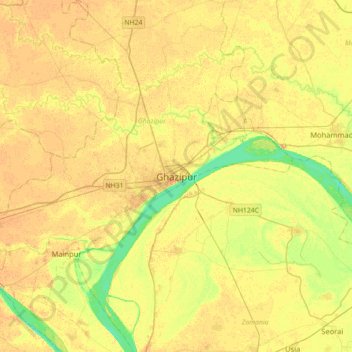
Name: Ghazipur topographic map, elevation, terrain.
Location: Ghazipur, Uttar Pradesh, 233001, India (25.42742 83.43040 25.74742 83.75040)
Average elevation: 68 m
Minimum elevation: 50 m
Maximum elevation: 77 m
Thank you for supporting this site ❤️
Make a donation
Make a donation