
Thank you for supporting this site ❤️
Make a donation
Make a donation
Llangoedmor topographic map
Click on the map to display elevation.
Thank you for supporting this site ❤️
Make a donation
Make a donation
Llangoedmor
Llangoedmor was the site of a 12th-century battle. Samuel Lewis's A Topographical Dictionary of Wales (1833) states.
Thank you for supporting this site ❤️
Make a donation
Make a donation
About this map
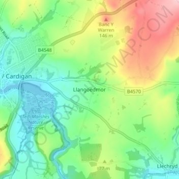
Name: Llangoedmor topographic map, elevation, terrain.
Location: Llangoedmor, Ceredigion, Wales, SA43 2LH, United Kingdom (52.06100 -4.64922 52.10100 -4.60922)
Average elevation: 60 m
Minimum elevation: -2 m
Maximum elevation: 169 m
Thank you for supporting this site ❤️
Make a donation
Make a donation