
Make a donation
Wudang topographic map
Click on the map to display elevation.
Make a donation
About this map
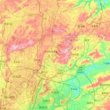
Name: Wudang topographic map, elevation, terrain.
Location: Wudang, Guiyang, Guizhou, China (26.57905 106.71702 26.91365 107.04834)
Average elevation: 1,265 m
Minimum elevation: 954 m
Maximum elevation: 1,620 m
Make a donation
Other topographic maps
Click on a map to view its topography, its elevation and its terrain.
Fanjing Mountain
China > Guizhou > Yinjiang Tujia and Miao Autonomous County
The Fanjingshan (Chinese: 梵净山; pinyin: Fànjìngshān) or Mount Fanjing, located in Tongren, Guizhou province, is the highest peak of the Wuling Mountains in southeastern China, at an elevation of 2,570 m (8,430 ft). The Fanjingshan National Nature Reserve was established in 1978 and designated a UNESCO…
Average elevation: 2,054 m
Make a donation
Make a donation
Make a donation
Make a donation
Fanjingshan
The Fanjingshan (Chinese: 梵净山; pinyin: Fànjìngshān) or Mount Fanjing, located in Tongren, Guizhou province, is the highest peak of the Wuling Mountains in southwestern China, at an elevation of 2,570 m (8,430 ft). The Fanjingshan National Nature Reserve was established in 1978 and designated a UNESCO…
Average elevation: 1,958 m
Make a donation
Make a donation
Make a donation
Shandong
China > Guizhou > Qiandongnan Miao and Dong Autonomous Prefecture > Shandong
Average elevation: 1,000 m
Yinjiang
China > Guizhou > Yinjiang Tujia and Miao Autonomous County > Yinjiang
Average elevation: 787 m
Make a donation
Bijie
Bijie borders Zunyi to the east, Anshun and Liupanshui to the south, Zhaotong and Qujing (Yunnan) to the west, and Luzhou (Sichuan) to the north. It spans latitude 26°21′−27°46′ N and longitude 105°36′−106°43′ E, and is marked heavily by the presence of the Wumeng Mountains (乌蒙山) as well…
Average elevation: 1,651 m