
Thank you for supporting this site ❤️
Make a donation
Make a donation
Les Crottes topographic map
Click on the map to display elevation.
Thank you for supporting this site ❤️
Make a donation
Make a donation
About this map
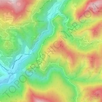
Name: Les Crottes topographic map, elevation, terrain.
Average elevation: 683 m
Minimum elevation: 319 m
Maximum elevation: 1,148 m
Thank you for supporting this site ❤️
Make a donation
Make a donation
Other topographic maps
Click on a map to view its topography, its elevation and its terrain.
La Vésubie
France > Provence-Alpes-Côte d'Azur > Alpes-Maritimes > Lantosque > Le Suquet
La Vésubie conflue entre les communes de Levens et Bonson, à environ 140 m d'altitude.
Average elevation: 545 m
Le Serre de Troupel
France > Provence-Alpes-Côte d'Azur > Alpes-Maritimes > Lantosque > Pélasque
Average elevation: 767 m