
Thank you for supporting this site ❤️
Make a donation
Make a donation
Strada in Chianti topographic map
Click on the map to display elevation.
Thank you for supporting this site ❤️
Make a donation
Make a donation
About this map
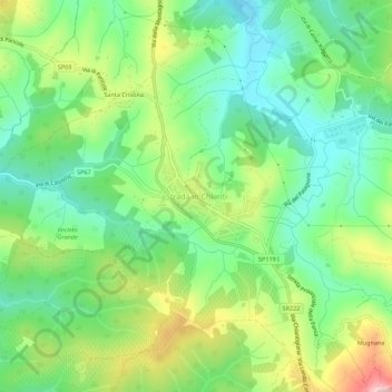
Name: Strada in Chianti topographic map, elevation, terrain.
Average elevation: 211 m
Minimum elevation: 124 m
Maximum elevation: 371 m
Thank you for supporting this site ❤️
Make a donation
Make a donation
Other topographic maps
Click on a map to view its topography, its elevation and its terrain.
Castello di Mugnana
Italy > Tuscany > Florence > Greve in Chianti > Chiocchio > Mugnana
Average elevation: 324 m