
Thank you for supporting this site ❤️
Make a donation
Make a donation
Gradinica topographic map
Click on the map to display elevation.
Thank you for supporting this site ❤️
Make a donation
Make a donation
About this map
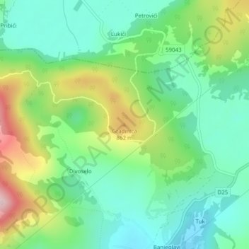
Name: Gradinica topographic map, elevation, terrain.
Location: Gradinica, Općina Udbina, Лицко-Сеньская жупания, Хорватия (44.69442 15.63422 44.69452 15.63432)
Average elevation: 741 m
Minimum elevation: 636 m
Maximum elevation: 959 m
Thank you for supporting this site ❤️
Make a donation
Make a donation
Other topographic maps
Click on a map to view its topography, its elevation and its terrain.
Perušić
Хорватия > Лицко-Сеньская жупания
Город Перушич расположен в юго-восточной части Лики, на высоте 575—600 метров, в долине реки Лика, в поле, огражденном холмами с запада от Клиса и железнодорожной веткой с востока от Старого города Перушича (хорв. Stari grad Perušića), именуемого также «городище» (хорв. Gradina).
Average elevation: 608 m
Thank you for supporting this site ❤️
Make a donation
Make a donation