
Thank you for supporting this site ❤️
Make a donation
Make a donation
Huanchu topographic map
Click on the map to display elevation.
Thank you for supporting this site ❤️
Make a donation
Make a donation
About this map
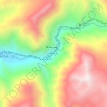
Name: Huanchu topographic map, elevation, terrain.
Location: Huanchu, Huaros, Canta, Lima, Perú (-11.42261 -76.53056 -11.38261 -76.49056)
Average elevation: 4,194 m
Minimum elevation: 3,612 m
Maximum elevation: 4,732 m
Thank you for supporting this site ❤️
Make a donation
Make a donation
Other topographic maps
Click on a map to view its topography, its elevation and its terrain.