
Thank you for supporting this site ❤️
Make a donation
Make a donation
Longwood topographic map
Click on the map to display elevation.
Thank you for supporting this site ❤️
Make a donation
Make a donation
About this map
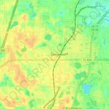
Name: Longwood topographic map, elevation, terrain.
Location: Longwood, Seminole County, Florida, 32750, United States (28.67962 -81.39162 28.72184 -81.32390)
Average elevation: 24 m
Minimum elevation: 7 m
Maximum elevation: 37 m
Thank you for supporting this site ❤️
Make a donation
Make a donation
Other topographic maps
Click on a map to view its topography, its elevation and its terrain.