
Hinche topographic map
Interactive map
Click on the map to display elevation.
About this map
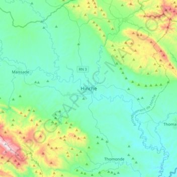
Name: Hinche topographic map, elevation, terrain.
Average elevation: 428 m
Minimum elevation: 183 m
Maximum elevation: 1,429 m
Other topographic maps
Click on a map to view its topography, its elevation and its terrain.
Dalmas
Haïti > Département du Centre > Commune Lascahobas
Dalmas, Commune Lascahobas, Arrondissement Lascahobas, Département du Centre, Haïti
Average elevation: 444 m
Thomassique
Haïti > Département du Centre > Thomassique
Thomassique, Arrondissement Cerca La Source, Département du Centre, Haïti
Average elevation: 277 m