
Lost Lake topographic map
Interactive map
Click on the map to display elevation.
About this map
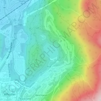
Name: Lost Lake topographic map, elevation, terrain.
Average elevation: 775 m
Minimum elevation: 636 m
Maximum elevation: 1,108 m
Other topographic maps
Click on a map to view its topography, its elevation and its terrain.
Alta Lake
Canada > British Columbia > Squamish-Lillooet Regional District > Whistler Resort Municipality > Whistler Village
Alta Lake, Nordic, Whistler Village, Whistler Resort Municipality, Squamish-Lillooet Regional District, British Columbia, Canada
Average elevation: 725 m