Geolocate

Petrified Forest National Park topographic map

Click on the map to display elevation.

Petrified Forest National Park

Averaging about 5,400 feet (1,600 m) in elevation, the park has a dry windy climate with temperatures that vary from summer highs of about 100 °F (38 °C) to winter lows well below freezing. More than 400 species of plants, dominated by grasses such as bunchgrass, blue grama, and sacaton, are found in the park. Fauna include larger animals such as pronghorns, coyotes, and bobcats; many smaller animals, such as deer mice, snakes, lizards, and seven kinds of amphibians; and more than 200 species of birds, some of which are permanent residents and many of which are migratory. About one third of the park is designated wilderness—50,260 acres (79 sq mi; 203 km2).

Wikipedia (CC-BY-SA 3.0)

About this map

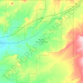
Name: Petrified Forest National Park topographic map, elevation, terrain.

Location: Petrified Forest National Park, Apache County, Arizona, 86028, United States (34.77889 -109.96878 35.17076 -109.57648)

Average elevation: 1,722 m

Minimum elevation: 1,591 m

Maximum elevation: 2,001 m

Other topographic maps

Click on a map to view its topography, its elevation and its terrain.

Sanders

United States > Arizona > Apache County

Average elevation: 1,801 m

Fort Defiance

United States > Arizona > Apache County

Average elevation: 2,130 m

East Mesa

United States > Arizona > Apache County

Average elevation: 2,093 m

Spider Rock

United States > Arizona > Apache County

Average elevation: 1,954 m

Concho

United States > Arizona > Apache County

Average elevation: 1,844 m

Greer

United States > Arizona > Apache County

Average elevation: 2,669 m

Lupton

United States > Arizona > Apache County

Average elevation: 1,942 m

Chambers

United States > Arizona > Apache County

Average elevation: 1,776 m

Vernon

United States > Arizona > Apache County

Average elevation: 2,119 m

Many Farms

United States > Arizona > Apache County

Average elevation: 1,641 m

Red Hill

United States > Arizona > Apache County

Average elevation: 1,830 m

Red Rock

United States > Arizona > Apache County

Average elevation: 1,780 m

Sawmill

United States > Arizona > Apache County

Average elevation: 2,354 m

Red Rock

United States > Arizona > Apache County

Average elevation: 1,780 m

Lukachukai

United States > Arizona > Apache County

Average elevation: 2,004 m

Vernon

United States > Arizona > Apache County

Average elevation: 2,119 m

Concho

United States > Arizona > Apache County

Average elevation: 1,844 m

Chinle

United States > Arizona > Apache County > Chinle

Average elevation: 1,715 m

Nutrioso

United States > Arizona > Apache County

Average elevation: 2,404 m

Toyei

United States > Arizona > Apache County

Average elevation: 1,993 m

Michigan Lake

United States > Arizona > Apache County

Average elevation: 1,888 m

St. Michaels

United States > Arizona > Apache County

Average elevation: 2,066 m

Concho

United States > Arizona > Apache County > Concho

Average elevation: 1,844 m

Eagle Crag

United States > Arizona > Apache County

Average elevation: 1,970 m

Red Rock

United States > Arizona > Apache County

Average elevation: 1,780 m