
Treyvaux topographic map
Interactive map
Click on the map to display elevation.
About this map
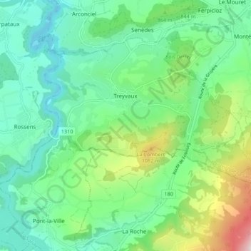
Name: Treyvaux topographic map, elevation, terrain.
Average elevation: 812 m
Minimum elevation: 592 m
Maximum elevation: 1,421 m
Other topographic maps
Click on a map to view its topography, its elevation and its terrain.
Villars-sur-Glâne
Zwitserland > Fribourg/Freiburg > District de la Sarine
Villars-sur-Glâne, District de la Sarine, Fribourg/Freiburg, 1752, Zwitserland
Average elevation: 654 m