
Ernonheid topographic map
Interactive map
Click on the map to display elevation.
About this map
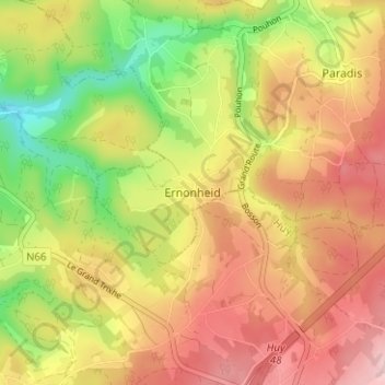
Name: Ernonheid topographic map, elevation, terrain.
Location: Ernonheid, Aywaille, Liège, Wallonie, 4920, Belgique (50.38295 5.64604 50.42295 5.68604)
Average elevation: 362 m
Minimum elevation: 237 m
Maximum elevation: 467 m
Other topographic maps
Click on a map to view its topography, its elevation and its terrain.
Remouchamps
Belgique > Liège > Liège > Aywaille
Remouchamps, Aywaille, Liège, Wallonie, 4920, Belgique
Average elevation: 222 m