
Thank you for supporting this site ❤️
Make a donation
Make a donation
Tanamawau topographic map
Click on the map to display elevation.
Thank you for supporting this site ❤️
Make a donation
Make a donation
About this map
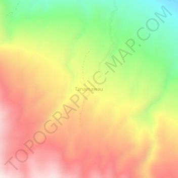
Name: Tanamawau topographic map, elevation, terrain.
Average elevation: 442 m
Minimum elevation: 18 m
Maximum elevation: 804 m
Thank you for supporting this site ❤️
Make a donation
Make a donation
Other topographic maps
Click on a map to view its topography, its elevation and its terrain.
Kepulauan Togean National Park
Indonesia > Central Sulawesi > Tojo Una-Una Regency
Average elevation: 4 m