
Río Ibáñez topographic map
Interactive map
Click on the map to display elevation.
About this map
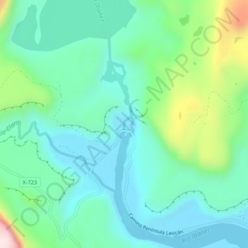
Name: Río Ibáñez topographic map, elevation, terrain.
Average elevation: 314 m
Minimum elevation: 203 m
Maximum elevation: 655 m
Other topographic maps
Click on a map to view its topography, its elevation and its terrain.
Lago Lapparent
Chile > Región Aysén del General Carlos Ibáñez del Campo > Río Ibáñez
Lago Lapparent, Cruce Ruta 7 - Lago Las Ardillas - Cruce X-735 (Cruce Levicán), Río Ibáñez, Provincia de General Carrera, Región Aysén del General Carlos Ibáñez del Campo, Chile
Average elevation: 931 m