
Thank you for supporting this site ❤️
Make a donation
Make a donation
Guardistallo topographic map
Click on the map to display elevation.
Thank you for supporting this site ❤️
Make a donation
Make a donation
About this map
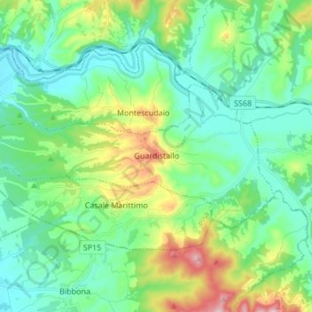
Name: Guardistallo topographic map, elevation, terrain.
Location: Guardistallo, Pisa, Tuscany, Italy (43.28970 10.54837 43.33524 10.68394)
Average elevation: 108 m
Minimum elevation: 10 m
Maximum elevation: 392 m
Thank you for supporting this site ❤️
Make a donation
Make a donation
Other topographic maps
Click on a map to view its topography, its elevation and its terrain.
Thank you for supporting this site ❤️
Make a donation
Make a donation
Thank you for supporting this site ❤️
Make a donation
Make a donation
Thank you for supporting this site ❤️
Make a donation
Make a donation