
Thank you for supporting this site ❤️
Make a donation
Make a donation
Thunandahena topographic map
Click on the map to display elevation.
Thank you for supporting this site ❤️
Make a donation
Make a donation
About this map
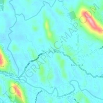
Name: Thunandahena topographic map, elevation, terrain.
Average elevation: 31 m
Minimum elevation: 7 m
Maximum elevation: 166 m
Thank you for supporting this site ❤️
Make a donation
Make a donation
Other topographic maps
Click on a map to view its topography, its elevation and its terrain.
Sinharaja Forest Reserve
Sri Lanka > Sabaragamuwa Province > Palinda-Nuwara (Baduraliya) DS Division
Average elevation: 374 m
Thank you for supporting this site ❤️
Make a donation
Make a donation
Thank you for supporting this site ❤️
Make a donation
Make a donation
Sinharaja Forest Reserve
Sri Lanka > Sabaragamuwa Province > Palinda-Nuwara (Baduraliya) DS Division
Average elevation: 374 m
Sinharaja Forest Reserve
Sri Lanka > Sabaragamuwa Province > Palinda-Nuwara (Baduraliya) DS Division
Average elevation: 374 m
Thank you for supporting this site ❤️
Make a donation
Make a donation