
Thank you for supporting this site ❤️
Make a donation
Make a donation
La Chevrais topographic map
Click on the map to display elevation.
Thank you for supporting this site ❤️
Make a donation
Make a donation
About this map
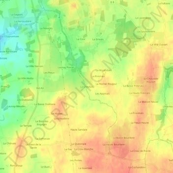
Name: La Chevrais topographic map, elevation, terrain.
Average elevation: 90 m
Minimum elevation: 59 m
Maximum elevation: 109 m
Thank you for supporting this site ❤️
Make a donation
Make a donation
Other topographic maps
Click on a map to view its topography, its elevation and its terrain.
Le parc de la Higourdais
France > Bretagne > Ille-et-Vilaine > Epiniac > Les Champs Sinants
Average elevation: 85 m