
Thank you for supporting this site ❤️
Make a donation
Make a donation
Muttenz topographic map
Click on the map to display elevation.
Thank you for supporting this site ❤️
Make a donation
Make a donation
About this map
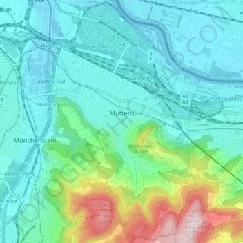
Name: Muttenz topographic map, elevation, terrain.
Location: Muttenz, Bezirk Arlesheim, Basel-Landschaft, 4132, Switzerland (47.49457 7.62158 47.55169 7.67509)
Average elevation: 341 m
Minimum elevation: 255 m
Maximum elevation: 666 m
Thank you for supporting this site ❤️
Make a donation
Make a donation
Other topographic maps
Click on a map to view its topography, its elevation and its terrain.