
Thank you for supporting this site ❤️
Make a donation
Make a donation
Lahuana topographic map
Click on the map to display elevation.
Thank you for supporting this site ❤️
Make a donation
Make a donation
About this map
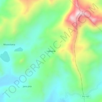
Name: Lahuana topographic map, elevation, terrain.
Location: Lahuana, Crucero, Carabaya, Puno, Perú (-14.41282 -69.75872 -14.37282 -69.71872)
Average elevation: 4,610 m
Minimum elevation: 4,404 m
Maximum elevation: 5,030 m
Thank you for supporting this site ❤️
Make a donation
Make a donation
Other topographic maps
Click on a map to view its topography, its elevation and its terrain.