
Municipalité de Bansko topographic map
Interactive map
Click on the map to display elevation.
About this map
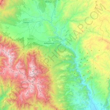
Name: Municipalité de Bansko topographic map, elevation, terrain.
Location: Municipalité de Bansko, Oblast de Blagoevgrad, Bulgarie (41.69278 23.36874 41.87302 23.83414)
Average elevation: 1,336 m
Minimum elevation: 510 m
Maximum elevation: 2,883 m
Other topographic maps
Click on a map to view its topography, its elevation and its terrain.
Municipalité de Yambol
Municipalité de Yambol, Oblast de Yambol, Bulgarie
Average elevation: 154 m
Roussé
Roussé, Municipalité de Roussé, Oblast de Roussé, Bulgarie
Average elevation: 64 m
Municipalité de Varna
Municipalité de Varna, Oblast de Varna, Bulgarie
Average elevation: 115 m
Khaskovo
Khaskovo, Municipalité de Khaskovo, Oblast de Khaskovo, Bulgarie
Average elevation: 218 m
Rojen
Bulgarie > Oblast de Blagoevgrad > Rojen
Rojen, Municipalité de Sandanski, Oblast de Blagoevgrad, 2820, Bulgarie
Average elevation: 582 m
Tchepelare
Tchepelare, Чепеларе, Oblast de Smolyan, 4850, Bulgarie
Average elevation: 1,398 m
Khaskovo
Bulgarie > Oblast de Khaskovo > Khaskovo
Khaskovo, Municipalité de Khaskovo, Oblast de Khaskovo, 6300, Bulgarie
Average elevation: 212 m
Plovdiv
Plovdiv, Municipalité de Plovdiv, Oblast de Plovdiv, 4000, Bulgarie
Average elevation: 287 m
Rila
Bulgarie > Oblast de Kyoustendil
Rila, Рила, Oblast de Kyoustendil, Bulgarie
Average elevation: 1,105 m
Svilengrad
Svilengrad, Свиленград, Oblast de Khaskovo, 6500, Bulgarie
Average elevation: 79 m
Pleven
Pleven, Municipalité de Pleven, Oblast de Pleven, 5805, Bulgarie
Average elevation: 190 m