
Thank you for supporting this site ❤️
Make a donation
Make a donation
Tayacucho topographic map
Click on the map to display elevation.
Thank you for supporting this site ❤️
Make a donation
Make a donation
About this map
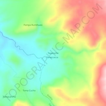
Name: Tayacucho topographic map, elevation, terrain.
Location: Tayacucho, Aucara, Lucanas, Ayacucho, Perú (-14.24840 -74.36303 -14.20840 -74.32303)
Average elevation: 4,109 m
Minimum elevation: 3,999 m
Maximum elevation: 4,270 m
Thank you for supporting this site ❤️
Make a donation
Make a donation
Other topographic maps
Click on a map to view its topography, its elevation and its terrain.