
Thank you for supporting this site ❤️
Make a donation
Make a donation
Ara topographic map
Click on the map to display elevation.
Thank you for supporting this site ❤️
Make a donation
Make a donation
About this map
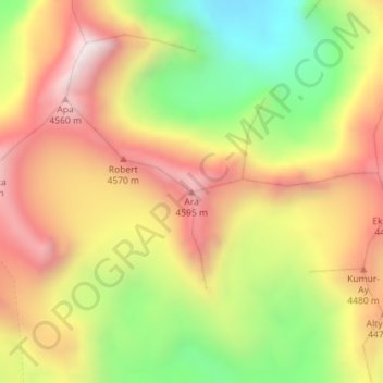
Name: Ara topographic map, elevation, terrain.
Location: Ara, Ат-Башы району, Gebiet Naryn, Kirgisistan (40.90136 75.64057 40.90146 75.64067)
Average elevation: 4,175 m
Minimum elevation: 3,666 m
Maximum elevation: 4,632 m
Thank you for supporting this site ❤️
Make a donation
Make a donation
Other topographic maps
Click on a map to view its topography, its elevation and its terrain.