
Thank you for supporting this site ❤️
Make a donation
Make a donation
Poljice topographic map
Click on the map to display elevation.
Thank you for supporting this site ❤️
Make a donation
Make a donation
About this map
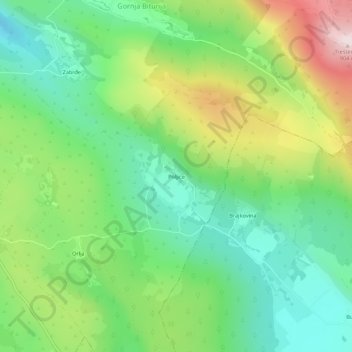
Name: Poljice topographic map, elevation, terrain.
Average elevation: 549 m
Minimum elevation: 355 m
Maximum elevation: 902 m
Thank you for supporting this site ❤️
Make a donation
Make a donation
Other topographic maps
Click on a map to view its topography, its elevation and its terrain.
Thank you for supporting this site ❤️
Make a donation
Make a donation
Приједор II / Prijedor II
Bosnia and Herzegovina > Republika Srpska > City of Prijedor > Приједор II / Prijedor II
Average elevation: 161 m