
Thank you for supporting this site ❤️
Make a donation
Make a donation
Portalegre topographic map
Click on the map to display elevation.
Thank you for supporting this site ❤️
Make a donation
Make a donation
About this map
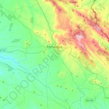
Name: Portalegre topographic map, elevation, terrain.
Location: Portalegre, Portugal (39.14624 -7.55853 39.39874 -7.23147)
Average elevation: 431 m
Minimum elevation: 208 m
Maximum elevation: 1,021 m
Thank you for supporting this site ❤️
Make a donation
Make a donation
Other topographic maps
Click on a map to view its topography, its elevation and its terrain.