
West Midlands topographic map
Click on the map to display elevation.
About this map
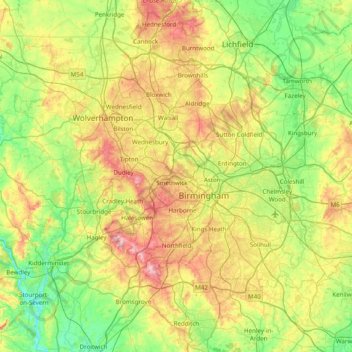
Name: West Midlands topographic map, elevation, terrain.
Average elevation: 113 m
Minimum elevation: 15 m
Maximum elevation: 307 m
Other topographic maps
Click on a map to view its topography, its elevation and its terrain.
Nuneaton Common
United Kingdom > England > Warwickshire > Nuneaton and Bedworth
Average elevation: 127 m
Rowington Green
United Kingdom > England > Warwickshire > Warwick > Rowington
Average elevation: 114 m
Brook End
United Kingdom > England > Warwickshire > North Warwickshire > Hurley
Average elevation: 107 m
Big Clowes Wood
United Kingdom > England > Warwickshire > Stratford-on-Avon > Tanworth in Arden CP
Average elevation: 152 m
Gilson
United Kingdom > England > Warwickshire > North Warwickshire > Coleshill CP
Average elevation: 82 m
Napton on the Hill
United Kingdom > England > Warwickshire > Stratford-on-Avon
Average elevation: 113 m
Pooley Country Park
United Kingdom > England > Warwickshire > North Warwickshire > Polesworth
Average elevation: 76 m
Hampton on the Hill
United Kingdom > England > Warwickshire > Warwick > Hampton on the Hill
Average elevation: 75 m
Burton Dassett Hills Country Park
United Kingdom > England > Warwickshire > Stratford-on-Avon > Northend > Burton Dassett CP
Average elevation: 132 m
Upper Quinton
United Kingdom > England > Warwickshire > Stratford-on-Avon > Lower Quinton
Average elevation: 70 m
Lye Green
United Kingdom > England > Warwickshire > Stratford-on-Avon > Claverdon
Average elevation: 106 m
Hartshill Hayes Country Park
United Kingdom > England > Warwickshire > North Warwickshire > Ansley Common
Average elevation: 127 m
Cranhill
United Kingdom > England > Warwickshire > Stratford-on-Avon > Ardens Grafton
Average elevation: 57 m
Curdworth Locks
United Kingdom > England > Warwickshire > North Warwickshire > Kingsbury > Curdworth CP
Average elevation: 80 m
Oversley Wood
United Kingdom > England > Warwickshire > Stratford-on-Avon > Alcester > Exhall
Average elevation: 64 m
Merevale Lake
United Kingdom > England > Warwickshire > North Warwickshire > Atherstone
Average elevation: 119 m
Church End
United Kingdom > England > Warwickshire > North Warwickshire > Ansley CP
Average elevation: 151 m
Edgehill
United Kingdom > England > Warwickshire > Stratford-on-Avon > Radway
Average elevation: 157 m
Sutton-under-Brailes
United Kingdom > England > Warwickshire > Stratford-on-Avon > Stourton
Average elevation: 125 m
Brinklow Marina
United Kingdom > England > Warwickshire > Rugby > King's Newnham CP
Average elevation: 95 m
Walton
United Kingdom > England > Warwickshire > Stratford-on-Avon > Wellesbourne
Average elevation: 76 m
Vale View
United Kingdom > England > Warwickshire > Nuneaton and Bedworth > Nuneaton
Average elevation: 113 m
Arlescote
United Kingdom > England > Warwickshire > Stratford-on-Avon > Warmington CP
Average elevation: 148 m
Bishopton
United Kingdom > England > Warwickshire > Stratford-on-Avon > Stratford-upon-Avon
Average elevation: 64 m
Holbech's Wood
United Kingdom > England > Warwickshire > North Warwickshire > Fillongley CP
Average elevation: 140 m
Hoar Park
United Kingdom > England > Warwickshire > North Warwickshire > Bentley CP
Average elevation: 135 m
Hunts Green
United Kingdom > England > Warwickshire > North Warwickshire > Middleton CP
Average elevation: 81 m
Marlcliff
United Kingdom > England > Warwickshire > Stratford-on-Avon > Bidford on Avon CP
Average elevation: 41 m
River Avon
United Kingdom > England > Warwickshire > Stratford-on-Avon > Stratford-upon-Avon > Clifford Chambers
Average elevation: 43 m
Ashorne
United Kingdom > England > Warwickshire > Stratford-on-Avon > Moreton Morrell
Average elevation: 67 m
Bishop's Itchington
United Kingdom > England > Warwickshire > Stratford-on-Avon
Average elevation: 105 m
Pillerton Hersey
United Kingdom > England > Warwickshire > Stratford-on-Avon > Pillerton Hersey
Average elevation: 92 m
Pathlow
United Kingdom > England > Warwickshire > Stratford-on-Avon > Wilmcote CP
Average elevation: 84 m
Lower Binton
United Kingdom > England > Warwickshire > Stratford-on-Avon > Binton
Average elevation: 52 m
Lea Marston Purification Lakes
United Kingdom > England > Warwickshire > North Warwickshire > Marston
Average elevation: 70 m
Horeston Grange
United Kingdom > England > Warwickshire > Nuneaton and Bedworth
Average elevation: 90 m
Ladbroke (Millennium Green)
United Kingdom > England > Warwickshire > Stratford-on-Avon > Ladbroke CP
Average elevation: 98 m
Winderton
United Kingdom > England > Warwickshire > Stratford-on-Avon > Winderton
Average elevation: 151 m