
Thank you for supporting this site ❤️
Make a donation
Make a donation
Soubey topographic map
Click on the map to display elevation.
Thank you for supporting this site ❤️
Make a donation
Make a donation
About this map
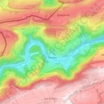
Name: Soubey topographic map, elevation, terrain.
Location: Soubey, District des Franches-Montagnes, Jura, 2887, Suisse (47.29335 7.00768 47.32831 7.08095)
Average elevation: 768 m
Minimum elevation: 456 m
Maximum elevation: 1,014 m
Thank you for supporting this site ❤️
Make a donation
Make a donation
Other topographic maps
Click on a map to view its topography, its elevation and its terrain.
Cerneux au Maire
Suisse > Jura > District des Franches-Montagnes > Les Bois
Average elevation: 1,027 m