
Thank you for supporting this site ❤️
Make a donation
Make a donation
Wetterfeld topographic map
Click on the map to display elevation.
Thank you for supporting this site ❤️
Make a donation
Make a donation
About this map
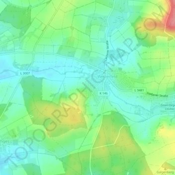
Name: Wetterfeld topographic map, elevation, terrain.
Location: Wetterfeld, Laubach, Landkreis Gießen, Hessen, Deutschland (50.53070 8.92675 50.56091 8.97499)
Average elevation: 212 m
Minimum elevation: 184 m
Maximum elevation: 270 m
Thank you for supporting this site ❤️
Make a donation
Make a donation
Other topographic maps
Click on a map to view its topography, its elevation and its terrain.
Wochenendgebiet Steinköppel
Deutschland > Hessen > Landkreis Gießen > Laubach
Average elevation: 433 m