
Make a donation
Lenore topographic map
Click on the map to display elevation.
Make a donation
About this map
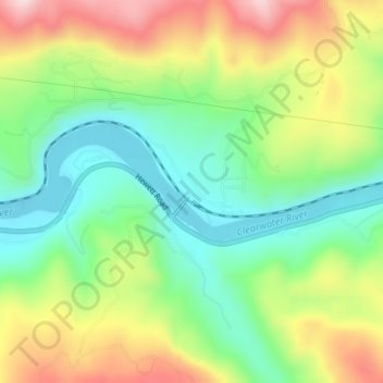
Name: Lenore topographic map, elevation, terrain.
Location: Lenore, Nez Perce County, Idaho, United States (46.49851 -116.56098 46.51851 -116.54098)
Average elevation: 401 m
Minimum elevation: 261 m
Maximum elevation: 609 m
Make a donation
Other topographic maps
Click on a map to view its topography, its elevation and its terrain.
Lewiston
United States > Idaho > Nez Perce County
According to the U.S. Census Bureau, the city has a total area of 18.04 square miles (46.72 km2), of which 17.23 square miles (44.63 km2) is land and 0.81 square miles (2.10 km2) is water. Downtown Lewiston, at elevations between 740 feet (230 m) and 780 feet (240 m), is only slightly higher in elevation than…
Average elevation: 334 m
Culdesac
United States > Idaho > Nez Perce County
Culdesac is located at 46°22′30″N 116°40′13″W / 46.37500°N 116.67028°W / 46.37500; -116.67028 (46.374883, -116.670333), at an elevation of 1,644 feet (501 m) above sea level.
Average elevation: 588 m