
Arnsberg topographic map
Interactive map
Click on the map to display elevation.
About this map
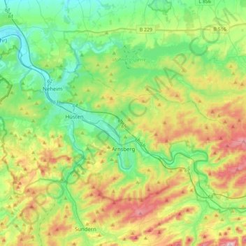
Name: Arnsberg topographic map, elevation, terrain.
Average elevation: 281 m
Minimum elevation: 137 m
Maximum elevation: 578 m
Other topographic maps
Click on a map to view its topography, its elevation and its terrain.
Winterberg
Allemagne > Rhénanie-du-Nord-Westphalie > Hochsauerlandkreis > Winterberg > Winterberg
Winterberg, Hochsauerlandkreis, Rhénanie-du-Nord-Westphalie, 59955, Allemagne
Average elevation: 648 m
Winterberg
Allemagne > Rhénanie-du-Nord-Westphalie > Hochsauerlandkreis
Winterberg, Hochsauerlandkreis, Rhénanie-du-Nord-Westphalie, 59955, Allemagne
Average elevation: 627 m
Schmallenberg
Allemagne > Rhénanie-du-Nord-Westphalie > Hochsauerlandkreis
Schmallenberg, Hochsauerlandkreis, Rhénanie-du-Nord-Westphalie, 57392, Allemagne
Average elevation: 511 m