
Make a donation
Meinerzhagen topographic map
Click on the map to display elevation.
Make a donation
Meinerzhagen
Meinerzhagen is located in the hills of the Sauerland. The highest elevation is the Nordhelle with 652 m above sea level, the lowest elevation at the Lister dam with 319m. 56% of the town area is covered by forests.
Make a donation
About this map
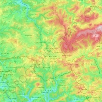
Name: Meinerzhagen topographic map, elevation, terrain.
Average elevation: 419 m
Minimum elevation: 252 m
Maximum elevation: 664 m
Make a donation
Other topographic maps
Click on a map to view its topography, its elevation and its terrain.
Rotthausen
Germany > North Rhine-Westphalia > Märkischer Kreis > Schalksmühle
Average elevation: 343 m
Gelstern
Germany > North Rhine-Westphalia > Märkischer Kreis > Schalksmühle > Heedfeld
Average elevation: 385 m
Moßberg
Germany > North Rhine-Westphalia > Märkischer Kreis > Menden (Sauerland)
Average elevation: 220 m
Make a donation
Blechen
Germany > North Rhine-Westphalia > Märkischer Kreis > Kierspe > Blechen
Average elevation: 376 m