
Schweicheln-Bermbeck topographic map
Interactive map
Click on the map to display elevation.
About this map
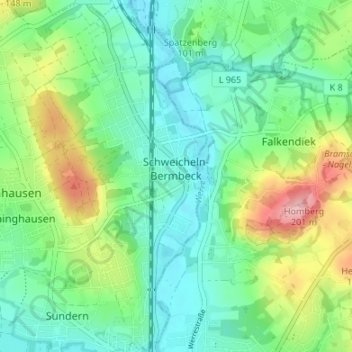
Name: Schweicheln-Bermbeck topographic map, elevation, terrain.
Average elevation: 100 m
Minimum elevation: 55 m
Maximum elevation: 203 m
Other topographic maps
Click on a map to view its topography, its elevation and its terrain.
Eilshausen
Deutschland > Nordrhein-Westfalen > Hiddenhausen
Eilshausen, Hiddenhausen, Kreis Herford, Regierungsbezirk Detmold, Nordrhein-Westfalen, 32120, Deutschland
Average elevation: 105 m