
Owerri Municipal topographic map
Interactive map
Click on the map to display elevation.
About this map
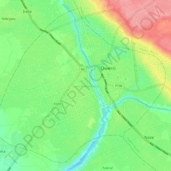
Name: Owerri Municipal topographic map, elevation, terrain.
Location: Owerri Municipal, Imo State, Nigeria (5.43808 6.97224 5.52212 7.06575)
Average elevation: 73 m
Minimum elevation: 40 m
Maximum elevation: 128 m
Other topographic maps
Click on a map to view its topography, its elevation and its terrain.
Owerri
Nigeria > Imo State > Owerri Municipal
Owerri, Owerri Municipal, Imo State, 460281, Nigeria
Average elevation: 88 m