
Thank you for supporting this site ❤️
Make a donation
Make a donation
Harrington Park topographic map
Click on the map to display elevation.
Thank you for supporting this site ❤️
Make a donation
Make a donation
About this map
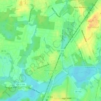
Name: Harrington Park topographic map, elevation, terrain.
Average elevation: 15 m
Minimum elevation: 2 m
Maximum elevation: 33 m
Thank you for supporting this site ❤️
Make a donation
Make a donation
Other topographic maps
Click on a map to view its topography, its elevation and its terrain.
River Edge
United States > New Jersey > Bergen County > River Edge > River Edge
Average elevation: 21 m
Thank you for supporting this site ❤️
Make a donation
Make a donation
Thank you for supporting this site ❤️
Make a donation
Make a donation
Thank you for supporting this site ❤️
Make a donation
Make a donation
New Bridge
United States > New Jersey > Bergen County > New Milford > New Bridge
Average elevation: 19 m
Wallington
United States > New Jersey > Bergen County > Wallington > Wallington
Average elevation: 23 m
Warren Point
United States > New Jersey > Bergen County > Fair Lawn > Warren Point
Average elevation: 22 m
Thank you for supporting this site ❤️
Make a donation
Make a donation
Ridgefield
United States > New Jersey > Bergen County > Ridgefield > Ridgefield
Average elevation: 24 m
Thank you for supporting this site ❤️
Make a donation
Make a donation