
Thank you for supporting this site ❤️
Make a donation
Make a donation
Magway topographic map
Click on the map to display elevation.
Thank you for supporting this site ❤️
Make a donation
Make a donation
About this map
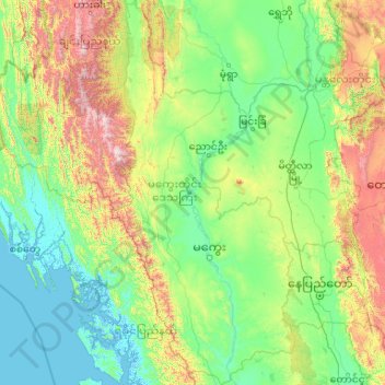
Name: Magway topographic map, elevation, terrain.
Location: Magway, Myanmar (18.83204 93.84551 22.77207 95.85919)
Average elevation: 393 m
Minimum elevation: -4 m
Maximum elevation: 2,985 m
Thank you for supporting this site ❤️
Make a donation
Make a donation
Other topographic maps
Click on a map to view its topography, its elevation and its terrain.