
Thank you for supporting this site ❤️
Make a donation
Make a donation
Hamberge topographic map
Click on the map to display elevation.
Thank you for supporting this site ❤️
Make a donation
Make a donation
About this map
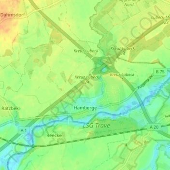
Name: Hamberge topographic map, elevation, terrain.
Average elevation: 16 m
Minimum elevation: -1 m
Maximum elevation: 32 m
Thank you for supporting this site ❤️
Make a donation
Make a donation
Other topographic maps
Click on a map to view its topography, its elevation and its terrain.
Thank you for supporting this site ❤️
Make a donation
Make a donation
Thank you for supporting this site ❤️
Make a donation
Make a donation
Thank you for supporting this site ❤️
Make a donation
Make a donation
Willinghusen
Deutschland > Schleswig-Holstein > Stormarn > Barsbüttel
Willinghusen liegt in einem Wasserschutzgebiet. Eine Gefährdung für dieses Wasserschutzgebiet geht von den umliegenden Deponien aus; auch bei der Anhöhe Katzenberg sollen Giftstoffe vergraben worden sein.
Average elevation: 36 m
Thank you for supporting this site ❤️
Make a donation
Make a donation