
Make a donation
Wincanton topographic map
Click on the map to display elevation.
Make a donation
About this map
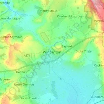
Name: Wincanton topographic map, elevation, terrain.
Location: Wincanton, Somerset, England, BA9 9LD, United Kingdom (51.01604 -2.45123 51.09604 -2.37123)
Average elevation: 102 m
Minimum elevation: 55 m
Maximum elevation: 245 m
Make a donation
Other topographic maps
Click on a map to view its topography, its elevation and its terrain.
Make a donation
Make a donation
Make a donation
Wiveliscombe
United Kingdom > England > Somerset
Wiveliscombe is a former borough, market and cloth making town, 5 miles (8 km) from the border between Devon and Somerset. It is situated at the foot of the Brendon Hills and acts as a gateway to Exmoor. At an altitude of 126 m (413 ft) Wiveliscombe is the highest town in Somerset after Dulverton.
Average elevation: 166 m
Make a donation
Make a donation
Glastonbury Tor
United Kingdom > England > Somerset > Glastonbury
The Tor is almost surrounded by the low-lying Somerset Levels, rising to an elevation of 518 feet (158 m). The Levels are reclaimed fen above which the Tor is clearly visible for miles around. It has been described as an island, but actually sits at the western end of a peninsula washed on three sides by the…
Average elevation: 33 m
Wiveliscombe
United Kingdom > England > Somerset
Wiveliscombe is a former borough, market and cloth making town, 5 miles (8 km) from the border between Devon and Somerset. It is situated at the foot of the Brendon Hills and acts as a gateway to Exmoor. At an altitude of 126 m (413 ft) Wiveliscombe is the highest town in Somerset after Dulverton.
Average elevation: 166 m
Make a donation
Glastonbury Tor
United Kingdom > England > Somerset > Glastonbury
The Tor is almost surrounded by the low-lying Somerset Levels, rising to an elevation of 518 feet (158 m). The Levels are reclaimed fen above which the Tor is clearly visible for miles around. It has been described as an island, but actually sits at the western end of a peninsula washed on three sides by the…
Average elevation: 33 m
Make a donation
Make a donation
Glastonbury Tor
United Kingdom > England > Somerset > Glastonbury
The Tor is in the middle of the Summerland Meadows, part of the Somerset Levels, rising to an elevation of 518 feet (158 m). The plain is reclaimed fen above which the Tor is clearly visible for miles around. It has been described as an island, but actually sits at the western end of a peninsula washed on…
Average elevation: 33 m
Make a donation
Kingsdown Clump
United Kingdom > England > Somerset > Roadwater > Nettlecombe
Average elevation: 178 m
Make a donation
Make a donation
Make a donation
Mells Park
United Kingdom > England > Somerset > Vobster
The architect Edwin Lutyens had known the Horners, and Mells Park, since 1896. In 1918 he unsuccessfully tried to persuade the Horners to rebuild Park House. However, Reginald McKenna, the chairman of Midland Bank, and formerly Home Secretary and Chancellor of the Exchequer under Asquith, was married to Pamela…
Average elevation: 134 m
Make a donation
Make a donation
Make a donation
Make a donation
Make a donation
Make a donation
Make a donation
Make a donation
Make a donation
Make a donation
Make a donation
Make a donation
Make a donation