
Thank you for supporting this site ❤️
Make a donation
Make a donation
Gunungwangi topographic map
Click on the map to display elevation.
Thank you for supporting this site ❤️
Make a donation
Make a donation
About this map
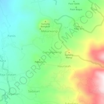
Name: Gunungwangi topographic map, elevation, terrain.
Location: Gunungwangi, Majalengka, West Java, Java, Indonesia (-6.90265 108.30317 -6.86265 108.34317)
Average elevation: 726 m
Minimum elevation: 446 m
Maximum elevation: 1,261 m
Thank you for supporting this site ❤️
Make a donation
Make a donation
Other topographic maps
Click on a map to view its topography, its elevation and its terrain.
lapangan GGM Majalengka
Indonesia > West Java > Majalengka > Majalengka Kulon
Average elevation: 109 m