
Make a donation
Seymour Mountain topographic map
Click on the map to display elevation.
Make a donation
About this map
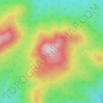
Name: Seymour Mountain topographic map, elevation, terrain.
Location: Seymour Mountain, Franklin County, New York, United States (44.15769 -74.17265 44.15779 -74.17255)
Average elevation: 928 m
Minimum elevation: 682 m
Maximum elevation: 1,236 m
Make a donation
Other topographic maps
Click on a map to view its topography, its elevation and its terrain.
Make a donation
Make a donation
Fish Creek Pond
United States > New York > Franklin County > Town of Santa Clara
Average elevation: 491 m
Village of Saranac Lake
United States > New York > Franklin County > Town of Harrietstown
Average elevation: 502 m
Make a donation
Make a donation
Village of Saranac Lake
United States > New York > Franklin County > Town of Harrietstown
Average elevation: 502 m
Fish Creek Pond Campground
United States > New York > Franklin County > Town of Santa Clara
Average elevation: 488 m
Make a donation
Town of Chateaugay
United States > New York > Franklin County > Town of Chateaugay
Average elevation: 280 m