
Make a donation
Cascadia topographic map
Click on the map to display elevation.
Make a donation
About this map
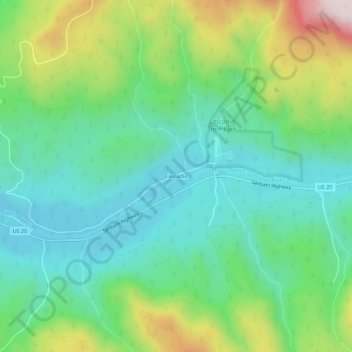
Name: Cascadia topographic map, elevation, terrain.
Location: Cascadia, Linn County, Oregon, 97329, United States (44.37729 -122.50724 44.41729 -122.46724)
Average elevation: 415 m
Minimum elevation: 235 m
Maximum elevation: 835 m
Make a donation
Other topographic maps
Click on a map to view its topography, its elevation and its terrain.
Albany
United States > Oregon > Linn County
According to the United States Census Bureau, the city has a total area of 17.75 square miles (45.97 km2), of which 17.54 square miles (45.43 km2) is land and 0.21 square miles (0.54 km2) is water. Albany has 21.7 square miles (56 km2) within its urban growth boundary. Throughout the city limits and urban…
Average elevation: 71 m
Make a donation
Santiam State Forest
United States > Oregon > Linn County
Elevations in Santiam State Forest range from 1,000 to 5,000 feet (1,500 m) above sea level. The terrain is characterized by long, steep slopes leading to broad ridge tops. Stream channels are common, and in most cases, have cut deeply into the hills. Higher elevations are rocky, especially on very steep…
Average elevation: 672 m
Make a donation
Albany
United States > Oregon > Linn County
According to the United States Census Bureau, the city has a total area of 17.75 square miles (45.97 km2), of which 17.54 square miles (45.43 km2) is land and 0.21 square miles (0.54 km2) is water. Albany has 21.7 square miles (56 km2) within its urban growth boundary. Throughout the city limits and urban…
Average elevation: 71 m
Make a donation
Albany
United States > Oregon > Linn County
According to the United States Census Bureau, the city has a total area of 17.75 square miles (45.97 km2), of which 17.54 square miles (45.43 km2) is land and 0.21 square miles (0.54 km2) is water. Albany has 21.7 square miles (56 km2) within its urban growth boundary. Throughout the city limits and urban…
Average elevation: 71 m