
Thank you for supporting this site ❤️
Make a donation
Make a donation
Blidstena topographic map
Click on the map to display elevation.
Thank you for supporting this site ❤️
Make a donation
Make a donation
About this map
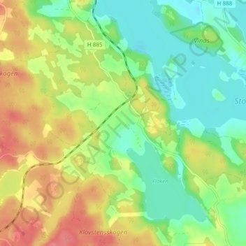
Name: Blidstena topographic map, elevation, terrain.
Location: Blidstena, Västerviks kommun, Kalmar län, Zweden (58.01540 16.35456 58.05540 16.39456)
Average elevation: 43 m
Minimum elevation: 11 m
Maximum elevation: 88 m
Thank you for supporting this site ❤️
Make a donation
Make a donation
Other topographic maps
Click on a map to view its topography, its elevation and its terrain.