
Thank you for supporting this site ❤️
Make a donation
Make a donation
Lohagad topographic map
Click on the map to display elevation.
Thank you for supporting this site ❤️
Make a donation
Make a donation
About this map
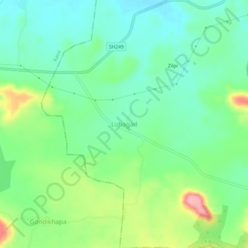
Name: Lohagad topographic map, elevation, terrain.
Location: Lohagad, Kalameshwar, Nagpur, Maharashtra, India (21.32259 78.70356 21.36259 78.74356)
Average elevation: 446 m
Minimum elevation: 407 m
Maximum elevation: 531 m
Thank you for supporting this site ❤️
Make a donation
Make a donation