
Thank you for supporting this site ❤️
Make a donation
Make a donation
Finale topographic map
Click on the map to display elevation.
Thank you for supporting this site ❤️
Make a donation
Make a donation
About this map
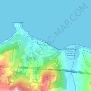
Name: Finale topographic map, elevation, terrain.
Location: Finale, Pollina, Palermo, Sicily, 90010, Italy (37.99988 14.14223 38.03988 14.18223)
Average elevation: 84 m
Minimum elevation: 0 m
Maximum elevation: 483 m
Thank you for supporting this site ❤️
Make a donation
Make a donation
Other topographic maps
Click on a map to view its topography, its elevation and its terrain.
Thank you for supporting this site ❤️
Make a donation
Make a donation
Thank you for supporting this site ❤️
Make a donation
Make a donation
Thank you for supporting this site ❤️
Make a donation
Make a donation
Thank you for supporting this site ❤️
Make a donation
Make a donation
Thank you for supporting this site ❤️
Make a donation
Make a donation
Corleone
Along the road that connects Corleone with Ficuzza, following the old railway line connecting Palermo to San Carlo (a hamlet of Chiusa Sclafani) (now the bike path), is an old bridge where the Frattina River streams between the limestone rocks. The erosive action of water has produced karst topography over…
Average elevation: 625 m
Thank you for supporting this site ❤️
Make a donation
Make a donation
Thank you for supporting this site ❤️
Make a donation
Make a donation
Thank you for supporting this site ❤️
Make a donation
Make a donation