
Hythe topographic map
Click on the map to display elevation.
About this map
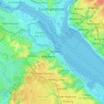
Name: Hythe topographic map, elevation, terrain.
Average elevation: 15 m
Minimum elevation: -5 m
Maximum elevation: 59 m
Other topographic maps
Click on a map to view its topography, its elevation and its terrain.
Hale Purlieu
United Kingdom > England > Hampshire > New Forest > Hatchet Green
Average elevation: 99 m
Woodgreen Common
United Kingdom > England > Hampshire > New Forest > Woodgreen
Average elevation: 57 m
Warwick Slade
United Kingdom > England > Hampshire > New Forest > Lyndhurst > Allum Green
Average elevation: 36 m
Lymington and Pennington
United Kingdom > England > Hampshire > New Forest > Lymington
Average elevation: 9 m
Newbridge Inclosure
United Kingdom > England > Hampshire > New Forest > Copythorne
Average elevation: 29 m
Monkton Mead
United Kingdom > England > Hampshire > New Forest > Breamore > South Charford
Average elevation: 52 m
Milford-on-Sea
United Kingdom > England > Hampshire > New Forest > Milford on Sea
Average elevation: 7 m