
Thank you for supporting this site ❤️
Make a donation
Make a donation
Cikidang topographic map
Click on the map to display elevation.
Thank you for supporting this site ❤️
Make a donation
Make a donation
About this map
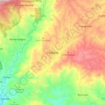
Name: Cikidang topographic map, elevation, terrain.
Location: Cikidang, Sukabumi, West Java, Java, Indonesia (-6.93548 106.60685 -6.85548 106.68685)
Average elevation: 464 m
Minimum elevation: 175 m
Maximum elevation: 770 m
Thank you for supporting this site ❤️
Make a donation
Make a donation
Other topographic maps
Click on a map to view its topography, its elevation and its terrain.